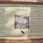
Mt. Shasta Ascent - Avalanche Gulch
It’s time to up the ante once again!
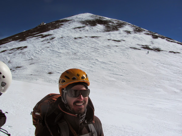
This past memorial day weekend, I went on my biggest, toughest hike yet! Mt. Shasta wasn’t just a “training hike” for the Rainier goal, but really, it was a goal all in itself. A good buddy who had climbed it last year talked me into going for it, and that late May was a great time to climb it. Well, I thought, why not? It would be good to go for a 14K peak well before Rainier. Even in the worst case, that’s still lots of great experience and an early warning about the pace of my training. In the best case, as it turned out, it’s an awesome climb with a beautiful backdrop! I did have to work very hard to push all the way to the top, but it’s very nice to know I can handle something with a Rainier-like elevation gain.
The Mountain, The Route
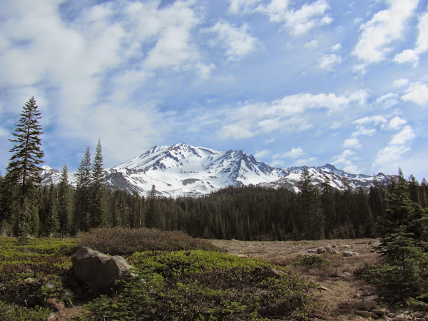
The basic facts are these: Standing at 14,179ft, Mt. Shasta is the second tallest mountain in the Cascades (behind Mt. Rainier by just a couple hundred feet). It’s also the largest by volume.
The climbing route of choice was Avalanche Gulch, which is basically a large valley formed by glacial erosion on the south face of the mountain. There currently isn’t any glacial ice on there, so the climb didn’t require glacier travel.
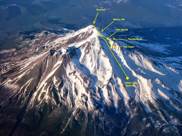
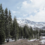
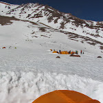
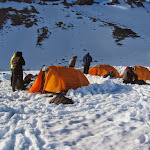
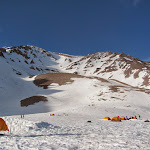
We did the climb in two days. First day just involves casually hiking to Helen Lake (actually quite a bit below Helen Lake), which is the standard camping ground for folks making their summit attempt on the south side. It’s a really crowded area, and people can sleep better at lower altitudes, so our guide company (Shasta Mountain Guides) usually chooses a lower elevation camp, maybe around 9,500ft.
On summit day, climbers switchback up the gulch, make a decision about whether to go left/right at The Heart, get to the top of the Red Banks, proceed to climb Misery Hill, and eventually make the final push to the summit.
The Team
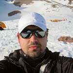
Originally, three of my friends were going to do this climb with me, but all had to bail a few weeks before, for various reasons. So, it was all me! I opted to save some money and just drive the 9-10 hours from/to Seattle. They had no problem filling the three spots, so we had a full group of 8 climbers going up. We also had three guides with us for the trip. I’m glad we had that kind of ratio, because we would not have been able to make it to the summit with any less!
Preparations
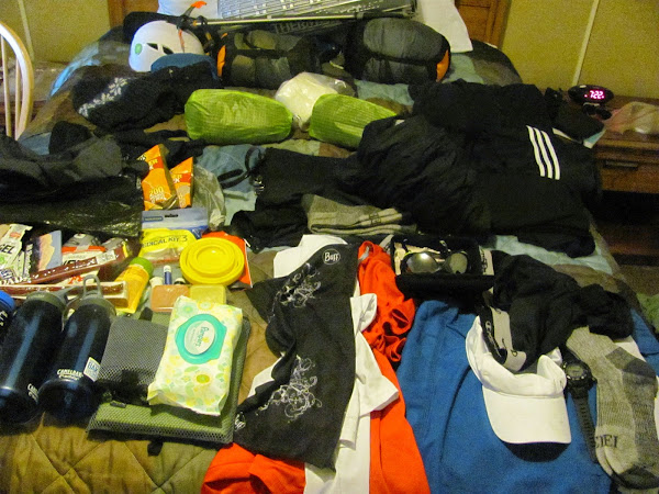
Friday (the 0th day) just involved some local hiking by myself, and preparing my pack. Organizing a backpack is one of those annoying chores that is so easy to procrastinate on.
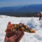
On an awesome tip from my buddy Ravi, I bought a large pizza, ate half for dinner, and packed the other half to eat on the trail during the first day. Having something tasty to eat makes a huge difference.
On Saturday morning, the group met up behind the Fifth Season (local REI-esque store). We went through a quick intro, gear check, splitting up and packing the shared gear, and proceeded to head on over to the trailhead. The Bunny Flat trailhead is a short drive away from the town.
The Climb - Day 1
The hike up to base camp was very easy. Our packs weighed roughly 50lbs, but the elevation gain to base camp was no more than maybe 2,000ft. The guides set a very nice, slow, super-sustainable pace.


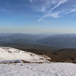
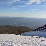
Once we made it to the camp site, the rest of the day was pretty simple. The guides did all of the tent setup, snow-melting and cooking work, while we hydrated and relaxed. There was a one hour snow school session to go over some of the basics, like French stepping, self-belay, self-arrest, etc. Since there is no glacier travel on this route, and we were going to short-rope all the way up, the snow skills lessons could remain very basic. Here’s some more photos from camp.

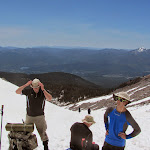
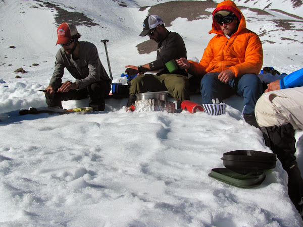
For dinner/eating, we had a nice square ditch all dug up, acting as a bench and a table. Here’s a shot of our fearless leaders at dinner. From left to right: Razor (Ryan), Matt, and Brian. Brian was the head honcho for the trip.
After a tasty meal of corn chowder and mac-n-cheese with vegetables and sausage, we all went to bed somewhere between 6-7 pm. I didn’t sleep at all. It turns out you don’t need to; as long as you are horizontal and relaxing, your body is recovering, and that’s what really matters. That’s good, because I seriously didn’t sleep a wink! I’m generally pretty bad at sleeping in tents, but I was also really excited about what was coming up next, early in the morning. Very early in the morning…
The Climb - Day 2
On Sunday “morning” (if 1 am qualifies as morning), the guides started going around camp, waking everyone up. I went through the moves I was mentally rehearsing for the last few hours: Open sleeping bag, sit up, turn on headlamp I had already attached to my helmet, grab the longer sleeve base layer sitting on my left and put it on, put on a hoodie, stretch, open inner tent door, hope the boots I stupidly left out in the vestibule didn’t freeze (they were fine, if a little cold), put them on, get into my gaiters, climbing harness, crampons, helmet… Outside, folks were putting the finishing touches on their packs, eating some oatmeal the guides had been making, and generally getting ready.

Since the snow was a bit punchy (thin layer of frozen crust with annoying soft snow underneath), we decided to leave ice axes on our packs, and start the trek with our hiking poles. And so, a little bit after 2am, we all head off, ready for a long day of climbing.
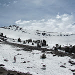
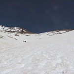
There was a nice clear sky of stars, and the night was just bright enough that we could faintly make out the mountain, though the headlamps drowned all of that out. About an hour into the hike, things started getting a bit steep, and it was time to stash the trekking poles. We ended up just leaving them there, lying on the ground, to be picked up on our descent. I thought were were farther along than we were at this point, but it turns out we had just reached Helen Lake. One of the important mental aspects of climbing in the dark is not to psyche yourself out by getting hopes up about how far you’ve gotten, because chances are, you’ve gotten seemingly nowhere.
Another hour in, and things had gotten steep enough to finally rope up. It is also at this point that the first turn-around happened, where one climber decided he would not be able to complete the climb. Every time that happens, a guide has to go down with them, so they asked if anyone else felt they need to turn around. Two more people raised their hands and said they want to turn around. So, after a bit of rope-switching, we were already down to five climbers and two guides. Onward!
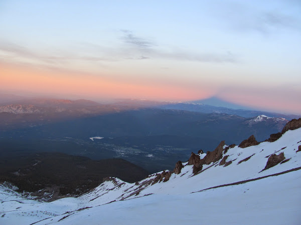
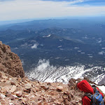
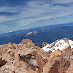
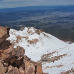
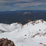
The two rope teams slowly continued to advance. The night was getting a little bit harsh, and there were some strong gusts of wind. Nothing that would knock anyone over, but enough to have to stop and brace yourself until it stopped. Another hour or two in, the sun started to come up, and the beauty that surrounded us literally came into light. One of my favourite sights was seeing Mt. Shasta’s long shadow in the sunrise.
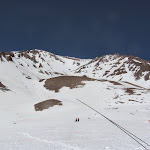
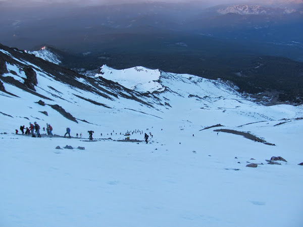
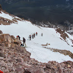
Looking down, we can see the climbers coming up in droves from the Lake Helen camp site. It’s a bit discouraging to still be able to see where we came from, but then you realize, “wait, I could see all the way up to Red Banks from camp, so of COURSE I can see all the way down to camp!”
The most challenging thing, at this point, was organizing myself while taking breaks. We’re on a roughly 45 degree slope at all times, and I was very paranoid about taking my pack off during breaks. I would bury my ice axe into the snow, always be holding it with one hand, and always be hooking my pack to it. Perhaps in the future, I’ll have a carabiner on my harness that I’ll use purely for backpack paranoia on summit day.
One of the decisions that has to be made on this climb is whether to go left or right at The Heart. That’s why the route I drew above has a fork in it. Going right at the heart is a slightly less steep journey, albeit longer, because you have to travel across the Red Banks. Going left is shorter, but much steeper. Depending on the season, some folks can go in between, and climb up one of the chimneys of the Red Banks. The main driver for the decision is rockfall. When a lot of people are above us right of the heart, there is a heightened risk of rocks rolling down the mountain, and our guides understandably didn’t want to contend with that stuff. Since there were a lot of people on this day, we decided to go left of the heart. That’s the hard way. :)
At about this point, a few discouraging things happened. Firstly, one of the climbers announced he was not feeling too good, and wanted to turn around. At about the same time, one of the other climbers had a wardrobe malfunction involving his crampons not being fitted quite right. It took a good 20 minutes to get it fixed on the slope. With that taken care of, Brian went down with the one climber that had to turn around. We were now down to four climbers, and one remaining guide (Matt).
Now, since the sun was coming up, we needed to make sure everyone had their glacier sunglasses ready to go. Somehow, one of the climbers had… crazy 80s aviator glasses (!!!) instead of proper glasses, which are darker than normal sunglasses and have proper shielding/coverage around the edges, to ensure no sunlight bounces off the snow and into the eyes from the sides. This is very important. With the sun blazing in a snowfield, it’s basically the same as having two suns, and the light bouncing off the snow can do a lot of damage over time. Matt was able to get some ghetto-style side-shields going with duct tape. Awesome, we’re off, finally!
And then, it happened. This climber turned to look at something, and… one of the lenses from his 80s aviator glasses FELL OUT! It just fell right out, and started rolling down the side of the mountain. It’s gone. Anything you aren’t holding onto is as good as gone. They drilled that in early. That water bottle you set down next to you while you take a picture? Good as gone! Eye protection is mission-critical on these climbs, so that means he has to turn around. While it sucks that this happened to him, I’m really glad it happened so soon after the previous climber turned around, because we were able to walkie-talkie Brian and have him wait for us to come down to him. There goes another half hour of progress.
After a final check that everyone had everything they need, we headed off. We were now down to three climbers with a single guide. We all knew that there was no more turning around. There is no G.I. Jane “ring out bell” at this point. If one turns around, we all turn around, and that’s that. None of us wanted to turn around, and we were probably all very tired; I know I certainly was. I just repeated to myself the mantra, “it’s a marathon, not a race,” because getting impatient with the slow pace and being tired is the worst mind trap I could fall into. I was very determined to keep fighting for this, and not turn around. It would have taken my body completely giving up from altitude to stop me. Until then, it’s one foot in front of the other.
We were on a bit of a time crunch, from the various little time-wasting incidents, and turn-around time is 11:30am. We were cutting it close, but also progressing at a great rate. If we kept up the pace, and were strict about breaks (1 hour on, 10 minutes off), we would make it to the summit, no problem. The left-of-the-heart steep terrain was relentless! Especially that last hour, where it got even steeper. Eventually, we cleared it, and it felt like a huge accomplishment all in itself. One of the more experienced climbers said something to the effect of, “I’ve climbed Denali and Everest… what the hell, that was so steep!!!”
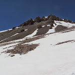
At this point, we had a little bit of flat terrain, and across that flat terrain, we were greeted with the last tough segment of this climb: Misery Hill. It’s a good name for it, too! Here’s Matt, with Misery Hill in the background.
Climbing Misery Hill is, all things considered, not too terrible. It’s easier than what we had to push through over the last couple of hours. What made it challenging was our mental state. After climbing up what was physically the hardest part of the climb, I started thinking of the victory as already achieved, so I had to get myself back into marathon mode after the small celebration to be able to push through it. The wind was also picking up. While it was a beautiful day, they did forecast stronger than normal winds (40-50mph). I had stupidly forgotten where my buff was (not sure why not on me), so I had to breathe into my free hand covering my face to warm up from the wind. During one segment, it was like being in a wind tunnel. It looked like an area that constantly has wind, from the shape of the mountain around it. The snow on the floor had frozen into shiny ice, indicating that the area is basically constantly being hit by wind. It was a little bit surreal walking through there.
Beyond Misery Hill, we could FINALLY see the summit. It looks more daunting than it really is, and we just needed to walk up another hill. As I got up there, signed the registry, and looked around, I felt an immense surge of pride for having pushed through this difficult climb.
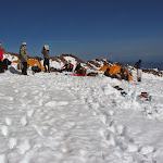
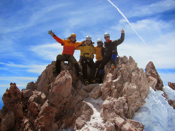
Here we are, the remaining four (of eleven) having made it to the summit:
And, of course, I had been joking the day before about saving a slice of pizza for the summit, so I ended up doing just that. Turtle Power! :D

The Descent
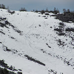
Going down the mountain was difficult. It was physically considerably easier and faster than coming up had been, but I had given my all in coming up. I was also very carefully rationing my water, drinking only “2 fingers” during the breaks, but I probably could have had a little bit more. I felt a little dehydrated coming down, with dry mouth. I did start drinking more water on the way down.
The way these climbs are timed is, you climb at night, while there is still a decent freeze, keeping the snow more solid to walk on, but then you come down around 11:00-noon, with the sun having had time to melt it a bit, which means there is ample opportunity for glissading. That’s the technical term for “sliding on your ass” and it’s a lot of fun. :)
We first had to climb down to the foot of the Red Banks (and we took the “right at the heart” route coming back; too dangerous to come back the way we came). During one steep segment, we had to rope back up, and I actually tripped and fell. The point of short-roping is that the guide (always the most uphill of the group) can simply catch you if you fall, but I also got a chance to practice my ice axe self-arrest in the process.
From the foot of Red Banks, we were able to glissade down all the way to Helen Lake, which made for a quick descent and a nice change of pace.
Once back to camp, and the proper amount of congratulations and fist-bumping were exchanged, we tore down camp, packed up and took off. This was also pretty hard. It’s not easy to motivate myself to move after all that! One of the aspects of the Rainier climb I’m looking forward to is spending one more night on the way down, so we can rest before packing up camp and heading out. The walk back to trailhead was an easy, uneventful downhill hike.
Lessons and Take-Aways
- Slow and steady! The number one thing that got me to the top is, “it’s a marathon, not a race.” Much of our training hikes have a very “go-go-go” hurry-up-and-wait nature. This is fine for training, but in the real deal, we’ll likely hit a slow but steady pace. It’s important for pace to be maintainable, and when it comes to mountaineering, that pace will be slower than many anticipate.
- Know your gear! And while we’re at it, have proper gear. Don’t cheap out, and don’t go ghetto style. Make sure you’ve tested everything, and make sure everything fits. Don’t kill your climb because of a stupid and preventable wardrobe malfunction.
- Not all elevation gain is the same. It’s very easy to look at summit day as if it will be easy, based on elevation gain during training hikes. “4,000ft? That’s just another mailbox, plus I have a lighter pack!” Not quite the same thing hehe.
- Yay altitude! I’m really happy that even on a short trip like this one, the altitude didn’t really get to me. Yes, the air is thinner, so I’m sure I got tired more quickly, but I wasn’t passing out from sickness. Of COURSE, that doesn’t necessarily mean much, because it can hit anyone at any time, but it gives me one more positive data point. The Rainier trip will be done over five days, rather than two, so all signs are looking good on that front.
Ok, enough out of me! You can also check out the full Mt. Shasta album, for pictures not shown on this trip report!